


The State
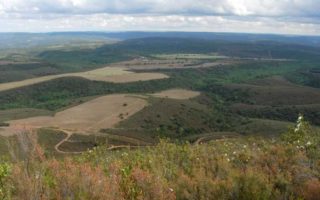
Ciguiñuelas a rustic estate, in Hontanar, Navas de Estena and Navalucillos, bordering to the north the Navalucillos municipal district and the Chorreras de Muelas property, starting from the point Carretera de Caballo, follows the Collado del Chorro until Rocigaldo following by the Collado de Castañuelas by Pico de la Torres, until the place called Calamocho.
To the South East Gargantilla and Avellanar estates, starting from the segregated property Cerro Alejo, continuing along the Ciguiñuelas stream until the confluence of the Alcornocal stream, towards its source, continuing towards the West by Los Morros crosses Río Frío river and goes straight to Cumbre de la Raña Duque, following towards the West, East, the Chorreras de Muelas estate, starting Calamocho continues to cross the road.
 To the South and making a jog follows El Postuero del Rebollaron and following the road to the south cross the Maíllo river and go making a jog to the west until Cercadillo, follow the south until the Cerro Alejo estate.
thumbnail South and making a jog follows the postuero of the Rebollaron and following bass of the highway towards South crosses the river Maillo, and continues to make a jog to the West up to the Cercadillo, continuing South to the segregated farm Hill Alejo.
To the West, Cañedos estate from Cumbre de la Raña del Duque along the Camino de Navalucillos to Horcajo de los Montes until the Casa de la Morra hill. Reach Navahermosa road, Portillo de Cíjara go straight to that roaduntil the Río Frío curve or Río Frío bridge, makes a jog to North by the Rotura del Tío Jorge hill, on the left Collado de las Tablas where parts towards the North through the Collados de la Redondita hills and the Larguita al Collado de las Estacas northwards that Hill up to the peak Carrera de Caballo of 1.409 metres.